NOAA Satellite Products Support Middle Peninsula Habitat Focus Area Efforts
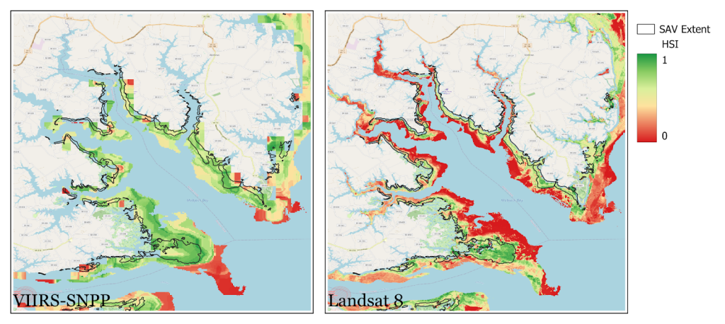
The Middle Peninsula Habitat Suitability Index is just one of the products developed using satellite data that helps restoration practitioners know more about the areas they aim to restore. Image by NOAA Satellites/Rachel Lazzaro, Seunghyun Son, Christopher Brown, Veronica Lance.
Much of the Middle Peninsula Habitat Focus Area centers on restoration projects in the area. NOAA and its partners collaborate on planning and implementing these projects that will bolster habitat as well as community resilience.
But how do the experts know precisely where, and how, to make these projects happen? NOAA satellite products help guide much of this restoration. Here are a few projects under way in the Middle Peninsula HFA.
Middle Peninsula Habitat Suitability Index
In the Chesapeake Bay, submerged aquatic vegetation (SAV) beds are an important part of the blue economy and ecosystem. They reduce wave action, reduce the effects of coastal runoff, and improve water quality. The use of satellite-derived water-quality data may provide a cost-effective way to understand the conditions in local SAV beds, as well as a way to determine where to target restoration activities.
We developed a Habitat Suitability Index (HSI) for SAV in Virginia’s Middle Peninsula by using satellite-derived water-quality data (including chlorophyll-a, turbidity, sea surface temperature, and diffuse attenuation coefficient—a measurement of how light dissipates with depth in the water column) from the Landsat 8 and VIIRS-SNPP satellites.
Salt Marsh Species Mapping
The Virginia Institute of Marine Science (VIMS) approached NOAA CoastWatch for assistance. VIMS wanted to develop satellite-based solutions for mapping saltmarsh species in the Middle Peninsula. The team used high spatial resolution, commercial satellite imagery from Planet’s PlanetScope satellites. They then used machine learning—a kind of artificial intelligence—to compare areas in the imagery with reference aerial imagery from VIMS of several kinds of saltmarsh species.
The machine learning process was successful. The process was able to identify some salt marsh plants, like black needlerush, phragmites, salt marsh hay, and salt marsh cordgrass. Being able to scale this effort up can help scientists identify where these species are so they can craft effective restoration projects.
Shoreline Change Product
We used images from the Landsat-5/7/8 and Sentinel-2A/B satellites from 1984 to 2021 to track the shoreline in the Middle Peninsula. Most of the studied coastline was subject to land loss (erosion): In some locations, usually along low-lying sandy beaches, erosion was more than 3 meters/year. The shorelines with man-made structures such as marinas, bulkheads, revetments, and offshore breakwaters changed less than did natural shorelines. Using satellites to track shorelines is an effective way to routinely check on shoreline changes.
