
Data Visualization Tool Informs Clean Up and Habitat Restoration in the Lower St. Louis River
Scientists and the public can access a comprehensive collection of standardized contaminant data from the Great Lakes to inform decisions and track the progress of restoration activities.
In the St. Louis River Estuary Habitat Focus Area, NOAA and our partners are cleaning up contaminated sediments and restoring habitat from historical industrial activities in the area. The team developed NOAA’s Great Lakes Data Integration Visualization Exploration and Reporting (DIVER) application to inform restoration decisions and track the progress of the effort. We’ve added hundreds of existing data sets to it.
The DIVER application presents the most comprehensive collection of standardized contaminant data from the Great Lakes—spanning nearly 40 years of data collection. Partners can now access data from more than 140 studies, including more than 700,000 samples and 80,000 toxicity tests results. This data can inform restoration activities in the lower St. Louis River.
Data Collection and Transition
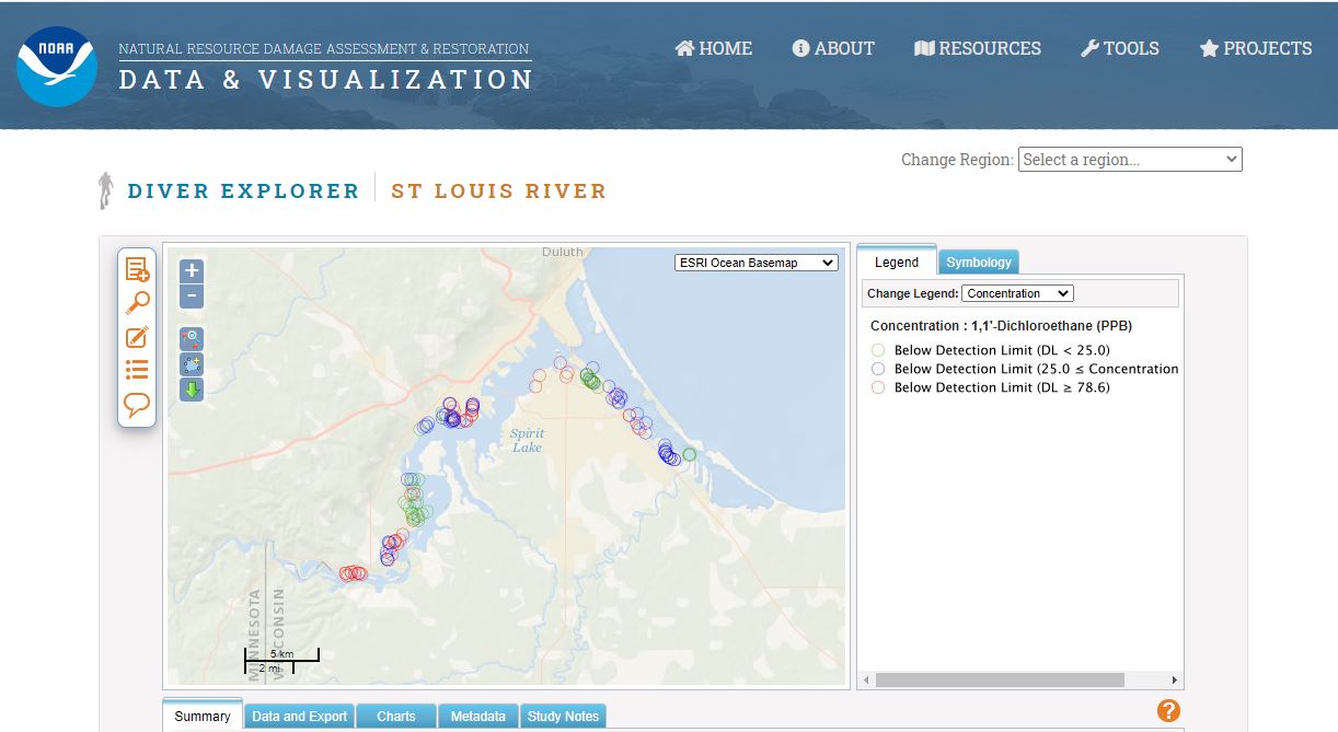
DIVER is a data warehouse and query tool. It allows natural resources managers and the public to access, visualize, and download extensive information on environmental pollution, sampling, and restoration efforts. The application integrates and standardizes data from many sources, and serves as a long-term host to store data online.
Since 2015, NOAA and our partners have been transitioning St. Louis River data sets into the Great Lakes DIVER application. The data sets are from federal and state agency studies on sediment contamination and other relevant chemical and biological studies. The team developed templates to ensure data submissions are consistent and efficient. They also developed query and visualization tools within DIVER that best serve the restoration teams in the region.
Data Informs Restoration
In addition to being a Habitat Focus Area, the St. Louis River is one of 31 Areas of Concern across the Great Lakes. This designation is given by the Environmental Protection Agency (EPA) to areas that have experienced environmental degradation. Data in DIVER can inform restoration efforts that will bring the St. Louis River closer to being removed from the list of Areas of Concern. Delisting occurs when all management actions needed to restore a damaged or degraded habitat have been completed.
In the St. Louis River Area of Concern, EPA research scientists have used DIVER to assess where sediment contamination is potentially contributing to fish consumption advisories. Using DIVER, the scientists queried contaminant and organic carbon data from surface sediment samples spanning a 25-year history of data collection. These data were used to identify potential “hot spots” where legacy contamination may be contributing to environmental degradation. This is a critical step toward removing the restrictions on consuming fish and wildlife in the area.
The Power of Partnerships
The efforts to transition data to DIVER, and to restore the lower St. Louis River, are being conducted by scientists and staff from:
- NOAA’s Office of Response and Restoration
- Minnesota Pollution Control Agency (MPCA)
- Wisconsin Department of Natural Resources
- EPA’s Great Lakes National Program Office
- EPA’s Office of Research and Development
As a result of the collaborative partnership behind DIVER, NOAA has also implemented a data service which provides MPCA’s Tableau sediment data visualization dashboard with updated data that can be visualized and downloaded. This data service can ultimately inform the state’s remediation and restoration efforts in the Area of Concern.
DIVER is maintained by NOAA’s Office of Response and Restoration. For more information, please contact orr.diver@noaa.gov.