Skip to content
NOAA Habitat Blueprint

NOAA Habitat Blueprint

  • About Habitat Blueprint
  • Habitat Focus Areas
    • About Habitat Focus Areas
    • Biscayne Bay, Florida
    • Choptank River Complex, Maryland/Delaware
    • Kachemak Bay, Alaska
    • Manell-Geus, Guam
    • Middle Peninsula, Virginia
    • Muskegon Lake, Michigan
    • NE Marine Corridor & Culebra Island, Puerto Rico
    • Penobscot River, Maine
    • Russian River, California
    • St. Louis River Estuary, Minnesota/Wisconsin
    • West Hawaiʻi
  • Living Shorelines
    • About Living Shorelines
    • Leading by Example
      • Beaufort, NC
      • Bainbridge Island, WA
      • Magnolia Springs, AL
      • Coxsackie, NY
    • Applying Science
      • Providing Reviews, Consultations & Permits
      • Tools for Planning
      • Conducting Research
      • Guidance, Training & Public Awareness
    • Building Partnerships
      • Non-Federal Partners
      • Federal Partners
      • Living Shorelines Project Map
  • News
  • Videos
  • Contact Us

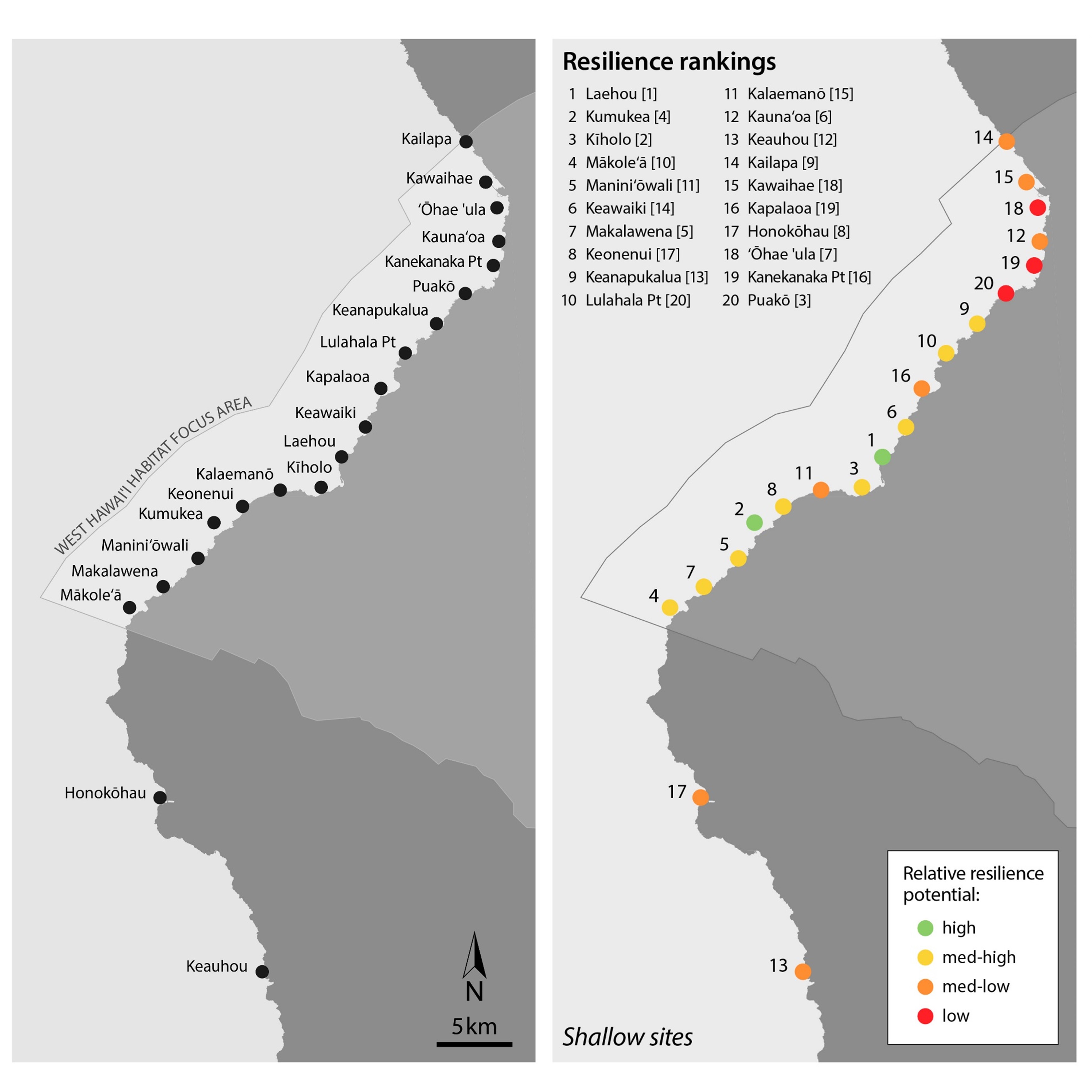
Left: Map of study sites in South Kohala, West Hawaiʻi where shallow and deep coral reefs were assessed within the NOAA West Hawaiʻi HFA and North Kona.

Right: Coral reef health and resilience rankings for each site. Healthier reefs more resilient to stress were observed in the southern portion of the West Hawaiʻi HFA, while less healthy and resilient reefs occurred further to the north.

  • Next →

NOAA Partner Offices

  • NOAA Fisheries
  • National Ocean Service
  • NOAA Research
  • Coral Reef Conservation Program
  • National Weather Service
  • Regional Collaboration Teams
  • Satellite & Information Service
Seal_of_the_United_States_Department_of_Commerce
Accessibility     |     EEO     |     FOIA     |     Information Quality     |     Policies & Disclaimer     |     Privacy Policy     |     USA.gov